Planning a Wild Cycling Route
Maps
If you want to plan a wild cycling route, you need to start with a map. My favourite maps for planning bike rides, and the ones that I think suit the needs of adventurous cyclists the best, are the Ordnance Survey (OS) 1:50,000 scale Landranger Map series. The series is available on memory-map GPS navigation software www.memory-map.co.uk. Using Memory Map software you can have the whole OS 1:50,000 scale Landranger Map series on your PC, laptop or other device. You can then upload any routes you plan to GPS navigation devices.
There are other very good maps and systems you can use. My preference for OS maps is because they were by far the best when I first started going out and exploring on two wheels. I was a teenager then and even I have to admit it was some time ago! I still enjoy doing it as much as ever though. Other mapping software is out there, and I’ve heard good things about lots of it, so go with what you think is best to plan your routes and find your way.
You might already plan your own routes and bike adventures. If not, I really hope you start doing so. There’s a joy from looking at a map and working out a way to cycle across it using off-road trails and back country lanes. Then there’s the satisfaction you get from riding the route you planned, and the added bonus of setting yourself a challenge, like I’ve done with the rides in my latest book, Really Wild Cycling.
Access rights
Before you start though, there are some things you need to know about access rights. The main off-road rights of way for cyclists in England and Wales are along bridleways, which are represented by long-dashed red lines on the OS 1:50,000 Landranger. Short-dashed red lines are footpaths and, at the moment, in England at least, cyclists aren’t allowed to ride along footpaths. Cycling access in Scotland is different and a little less restrictive, so long as you follow guidelines you will find on www.outdooraccess.scot
Many of the rides in Really Wild Cycling use bridleways, but I have also used tiny lanes, shown in yellow on Landranger maps, the width of the yellow line being broadly proportional to the width of the lane. I have also used designated cycle routes created by bodies such as Sustrans, the creator of the National Cycle Network. There are other small lanes, which are shown by parallel narrow black lines on Landranger, however, these lanes sometimes have local rights in force, and occasionally they are the private drive to a house or farm. The only lanes I use in Really Wild Cycling are those where I’m sure there is a cyclist right of way. When planning your own routes, if you have to use a surfaced lane it’s better to stick to the yellow ones, or those that are part of a designated cycle route.
A word on GPS
Finally, before moving on from maps planning and finding your way, there is another big thing to mention: GPS devices are a great help, but you should not rely on them totally. You should still take a paper map with you and a compass, especially when going high up or far away. Satellite coverage cannot be relied on everywhere, especially in far off places. Paper maps and a standard compass will never let you down. You can print the maps from your screen if you don’t want the bother of unfolding and folding a standard map. Always use a plastic map sleeve to put your map or maps in. They are cheap and are available in most outdoor shops.
Learning to read maps
With a map and a compass you always know where you are. OS maps are orientated roughly north to south. So lay the map out, place the compass on top of it and line the top of the map up with where the compass points north. Face that direction. The map is then roughly oriented, and you should be able to relate the features illustrated on it to the features you can see around you. It won’t be perfect, but it’s a helpful start.
It’s worth getting to know more about maps so you can develop your skill at using them. There’s a lot of information about map reading online – the website www.maptools.com is excellent. You could also enrol on a good map reading course. It’s really worth signing up to one if you are unsure how to fully use OS maps and get the most from them.
Other equipment
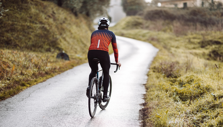
A map and compass fit easily into standard cycling jerseys, and it is important to use specific cycling kit, not normal outdoor clothes, and dress appropriately according to the weather. Check two weather forecasts before long wild rides, and if you are going high always carry a cycling-specific rucksack.
It doesn’t need to be a big rucksack, but it should contain a full set of waterproof and windproof clothing and extra gloves in case the weather turns really bad. You can’t be too cautious when taking on a bit of wild cycling. In the one competitive event I’ve included in Really Wild Cycling, the Three Peaks cyclo-cross, the organisers insist competitors carry a survival blanket and a whistle. Both will help them stay alive if they fall or get lost.
High, wild places are a joy to experience, but the potential danger involved with being there is real. Even on bright, warm sunny days in summer the weather can change quickly in high places. If you are above 300 metres or 1,000 feet in Britain it can suddenly get cold, especially if it rains, even in summer. Extra clothing and extra food are both essential. Take a first aid kit and whistle to attract attention if you have an accident. It’s safer to do high, lonely rides in company with others, especially if you are inexperienced in that environment.
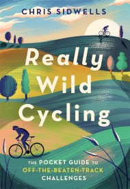
An illustrated pocket guide to off-the-beaten-track cycling challenges
Really Wild Cycling follows in the tracks of Chris's bestselling Wild Cycling. Most, if not all, the rides are off-road, but each one presents a challenge to inspire readers to train for it and have a go. Most take only a few hours, but some are longer, and a few much longer, taking even the fittest several days. An introduction explains safety techniques and underlines the skills, knowledge, equipment and fitness levels required. The rides are graded in ascending difficulty within each region. Each ride suggests regular escape points to get riders to a safe place should the weather close in and draws attention to places where extra care should be taken. Some rides are on marked routes, like the Trans-Pennine Trail, some are races or organised challenges, while others are routes the author himself has mapped out. Each ride is illustrated with photos, an annotated map and a profile of the terrain. The text includes a detailed route guide and historical, geological and natural points of interest.